
CAD in urban development improves design accuracy and efficiency of city operations. It allows for detailed 2D and 3D models that improve visualization and communication for city planning. CAD software enables faster design modifications, better collaboration among professionals, and reduced costs by minimizing errors and optimizing material usage.
Ultimately, CAD in construction and planning facilitates the creation of more functional, sustainable, and cost-effective urban plans and high-quality infrastructure projects. If you want to work with an urban development team, specializing in drafting and design, earn an associate degree in drafting and design technology.
Computer-Aided Drafting Enhances Visualization
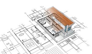
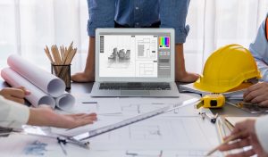 CAD creates detailed 2D and 3D models, allowing urban planners and stakeholders to visualize the entire project from planning to completion, improving understanding of complex urban designs and development. Employees working in offices, on job sites, remotely from home, and from their vehicles can easily visualize the same projects and collaborate.
Although paper sketches and drawings may be used initially, CAD renderings take over the job of visualizing the essential projects, modifications, and end products in city planning. As technologies advance, this part of urban planning will come to life more dramatically.
Improved Accuracy, Error Reduction, And Collaboration With Computer-Aided Drafting
The precision of CAD software minimizes errors common in manual drafting, reducing costly mistakes during construction and leading to higher quality outcomes. Collaborative efforts to make changes are enhanced with a high level of accuracy and consistency among multiple project participants.
Cloud-based and easily exchangeable CAD files allow multiple designers, architects, engineers, and stakeholders to work on the same project simultaneously, improving teamwork and communication. CAD software provides a central location for accessing design data, making it easier to save, edit, send, and print designs, which streamlines workflows.
|
“Ultimately, CAD facilitates the creation of more functional, sustainable, and cost-effective urban plans and high-quality infrastructure projects.” |
Experience Increased Efficiency And Time Savings
Automation of repetitive tasks and rapid design modifications significantly speed up the planning process, saving time and resources. Collaboration and data sharing in city planning streamline the virtual prototyping, which shortens the time-to-market and project completion.
CAD capabilities allow engineers, designers, and construction managers to quickly iterate on designs, detect errors early, and directly transfer designs to architecture and construction departments. These efforts ultimately lead to faster development and higher-quality urban planning results. Greater efficiency reduces project costs and helps minimize raising taxes.
Cost Reduction Benefits Help Urban Budgets
By identifying conflicts, optimizing material usage, and reducing the need for physical prototypes, CAD helps lower overall planning and construction costs. Urban development software can be used in partnership with strategies that focus on:
- Efficient land use
- Streamlining approval processes
- Adopting new construction technologies
- Leveraging alternate financing models
- Using sustainable materials
- Shortening long-term operations
- Sustaining long-term cost-effective growth
City planners can redevelop underutilized urban spaces that are often cheaper than building on new land. Repurposing existing buildings can save resources, money, and preserve community character. CAD in construction and planning helps keep budgets in line with original plans.
CAD Facilitates Simulation And Analysis
 CAD enables the creation of virtual urban prototypes and simulations, allowing for stress and flow analysis, and the simulation of construction timelines and costs. 3D models let planners perform and analyze simulations, such as:
- Traffic flow: public transport, walking, biking, and private auto
- Environmental impact: air circulation, natural light, and noise
- Disaster scenarios: tornadoes, floods, earthquakes
- Optimal land use: currently owned and new purchases
- Infrastructure performance: housing, streets, public utilities
- Streamline the design review process
Sustainable And Resilient Design Is Supported
The ability to create detailed and efficient models for architecture and construction helps planners design more functional, affordable, and sustainable cities and infrastructure. Performance modeling is achieved with advanced software like Autodesk Insight to perform energy modeling and assess the sustainability of their designs. Other tools like Rhino and Grasshopper enable parametric analysis of urban components, optimizing their environmental factors and resiliency.
In conclusion, CAD in Urban Development supports sustainable and resilient urban design by providing powerful tools for simulation, analysis, and visualization. CAD in urban development moves the process from manual drawing to data-driven design, allowing urban planners to optimize resource use, reduce environmental impact, and create more durable, livable urban spaces. Contact ITI Technical College today for more information.
Drafting And Design Technology Training
Career aspirations are enhanced with the right type of technical education and training. ITI Technical College has graduated thousands of technical students since 1973. If you want a career in drafting and design, enroll in our Associate of Occupational Studies (AOS) Degree in the Drafting and Design Technology Program. It will prepare you for entry-level positions in various industries that need your skills.
For more information about graduation rates, the median debt of students who completed the program, and other important information, please visit our website: https://iticollege.edu/disclosures/